Zagros Mountains
The Zagros range is about 990 miles (1,600 km) long and more than 150 miles (240 km) wide. Situated mostly in what is now Iran, it forms the extreme western boundary of the Iranian plateau, though its foothills to the north and west extend into adjacent countries.
The oldest rocks in the Zagros range date to Precambrian time (that is, before 541 million years ago), and the Paleozoic Era rocks that date to between 541 million and 252 million years ago are found at or near the highest peaks. Most of the rocks in the mountain range, however, are limestone and shale from the Mesozoic Era (252 million to 66 million years ago) and the Paleogene Period (66 million to 23 million years ago). The range was primarily formed by orogenies (mountain-building episodes) driven by the movement of the Arabian Plate underneath the Eurasian Plate during the Miocene and Pliocene epochs (23 million to 2.6 million years ago).
The highest point in the range is Mount Dena, elevation 14,465 feet (4,409 metres), located in the middle Zagros. Passes through the mountains are used for reaching the fertile intermontane plains, which lie at elevations above 5,000 feet (1,500 metres). The rivers draining the range’s western face are strong and perennial, flowing through enclosed plains or ravines. Rainfall in the region is about 40 inches (1,000 mm) annually.
The mountains are an imposing natural barrier and have traditionally provided the boundary between cultural and political entities, including the early Mesopotamian and Median cultures, the Parthian and Roman empires, and, more recently, the Persian and Ottoman empires. The mountains and foothills that approach the range are home to a significant portion of Iran’s population, including, in addition to ethnic Persians, significant numbers of Assyrian Christians, Kurds, and Turks as well as Lurs, Bakhtyārī, and Qashqāʾī tribal groups. The traditional economy is based largely on animal husbandry, and the production of high-quality rugs and carpets has long been a mainstay of the region. Large reserves of petroleum are located in or near the southwestern foothills.
Iran, a mountainous, arid, and ethnically diverse country of southwestern Asia. The country maintains a rich and distinctive cultural and social continuity dating back to the Achaemenian period, which began in 550 bce. Since 1979 it has become known for its unique brand of Islamic republic. Although the system of government was intended as a parliamentary democracy, persistent instability both at home and abroad have steered its slide into a more theocratic authoritarianism. In 2022 the state’s push to pacify economic unrest through repression prompted widespread and debilitating protests, which were catalyzed in part by the death of Jina Mahsa Amini while she was in custody for improper attire. The repression that was seen before, during, and after those protests coincided with questions over the succession of the aging Ali Khamenei, the autocratic leader (rahbar) for more than three decades.
Geographically, much of Iran consists of a central desert plateau, which is ringed on all sides by lofty mountain ranges that afford access to the interior through high passes. Most of the population lives on the edges of this forbidding waterless waste. The capital is Tehrān, a sprawling jumbled metropolis at the southern foot of the Elburz Mountains. Famed for its handsome architecture and verdant gardens, the city fell somewhat into disrepair in the decades following the Iranian Revolution of 1978–79, though efforts were later mounted to preserve historic buildings and expand the city’s network of parks. As with Tehrān, cities such as Eṣfahān and Shīrāz combine modern buildings with important landmarks from the past and serve as major centers of education, culture, and commerce.
The heart of the storied Persian empire of antiquity, Iran has long played an important role in the region as an imperial power and later—because of its strategic position and abundant natural resources, especially petroleum—as a factor in colonial and superpower rivalries. From the Achaemenian period the region that is now Iran—traditionally known as Persia—has been influenced by waves of indigenous and foreign conquerors and immigrants, including the Hellenistic Seleucids and native Parthians and Sasanids. Persia’s conquest by the Muslim Arabs in the 7th century was to leave the most lasting influence, however, as Iranian culture was all but completely subsumed under that of its conquerors.
An Iranian cultural renaissance in the late 8th century led to a reawakening of Persian literary culture, though the Persian language was now highly Arabized and in Arabic script, and native Persian Islamic dynasties began to appear with the rise of the Ṭāhirids in the early 9th century. The region fell under the sway of successive waves of Persian, Turkish, and Mongol conquerors until the rise of the Safavids, who introduced Twelver Shiʿism as the official creed, in the early 16th century. Over the following centuries, with the state-fostered rise of a Persian-based Shiʿi clergy, a synthesis was formed between Persian culture and Shiʿi Islam that marked each indelibly with the tincture of the other.
With the fall of the Safavids in 1736, rule passed into the hands of several short-lived dynasties leading to the rise of the Qājār line in 1796. Qājār rule was marked by the growing influence of the European powers in Iran’s internal affairs, with its attendant economic and political difficulties, and by the growing power of the Shiʿi clergy in social and political issues.
The country’s difficulties led to the ascent in 1925 of the Pahlavi line, whose ill-planned efforts to modernize Iran led to widespread dissatisfaction and the dynasty’s subsequent overthrow in the revolution of 1979. This revolution brought a regime to power that uniquely combined elements of a parliamentary democracy with an Islamic theocracy run by the country’s clergy. The world’s sole Shiʿi state, Iran found itself almost immediately embroiled in a long-term war with neighboring Iraq that left it economically and socially drained, and the Islamic republic’s alleged support for international terrorism left the country ostracized from the global community. Reformist elements rose within the government during the last decade of the 20th century, opposed both to the ongoing rule of conservative clergy and to Iran’s continued political and economic isolation from the international community. Their rise was reversed in the 21st century, however, owing to intervention from the conservative leadership and the greater penetration of the Islamic Revolutionary Guard Corps (IRGC) throughout government and society.
Iran is bounded to the north by Azerbaijan, Armenia, Turkmenistan, and the Caspian Sea, to the east by Pakistan and Afghanistan, to the south by the Persian Gulf and the Gulf of Oman, and to the west by Turkey and Iraq. Iran also controls about a dozen islands in the Persian Gulf. About one-third of its 4,770-mile (7,680-km) boundary is seacoast.
A series of massive, heavily eroded mountain ranges surrounds Iran’s high interior basin. Most of the country is above 1,500 feet (460 meters), with one-sixth of it over 6,500 feet (1,980 meters). In sharp contrast are the coastal regions outside the mountain ring. In the north a strip 400 miles (650 km) long bordering the Caspian Sea and never more than 70 miles (115 km) wide (and frequently narrower) falls sharply from 10,000-foot (3,000-meter) summits to the marshy lake’s edge, some 90 feet (30 meters) below sea level. Along the southern coast the land drops away from a 2,000-foot (600-meter) plateau, backed by a rugged escarpment three times as high, to meet the Persian Gulf and the Gulf of Oman.
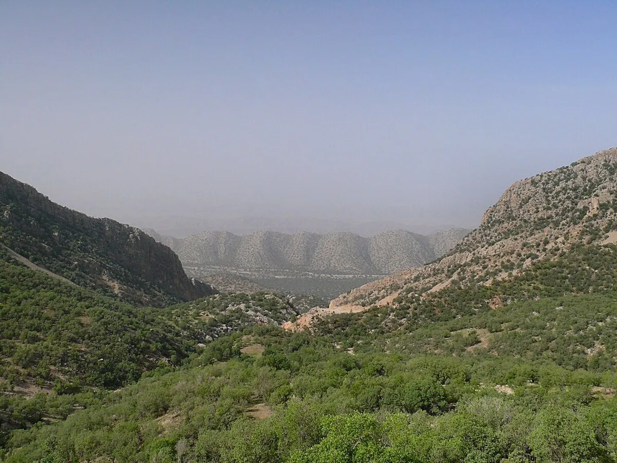
The Zagros (Zāgros) Mountains stretch in a northwest-southeast direction, from Iran’s borders with Turkey and Iraq in the northwest to the Strait of Hormuz in the southeast. Farther to the south the range broadens into a band of parallel ridges 125 miles (200 km) wide that lies between the plains of Mesopotamia and the great central plateau of Iran. The range is drained on the west by streams that cut deep narrow gorges and water fertile valleys. The land is extremely rugged and difficult to access and is populated largely by pastoral nomads.
The Elburz (Alborz) Mountains run along the south shore of the Caspian Sea to meet the border ranges of the Khorāsān region to the east. The tallest peak in the chain is the snow-clad Mount Damāvand (Demavend), which is also Iran’s highest point. Many parts of Iran are isolated and poorly surveyed, and the elevation of many of its peaks are still in dispute; the height of Mount Damāvand is generally given as 18,605 feet (5,671 meters).
Volcanic and tectonic activity
Mount Taftān, a massive cone reaching 13,261 feet (4,042 meters) in southeastern Iran, emits gas and mud at sporadic intervals. In the north, however, Mount Damāvand has been inactive in historical times, as have Mount Sabalān (15,787 feet [4,812 meters]) and Mount Sahand (12,172 feet [3,710 meters]) in the northwest. The Sahand-Bazman Belt, formed by Eocene volcanism, extends some 1,200 miles (1,900 km) from the border with Azerbaijan in the northwest to Baluchistan in the southeast and includes volcanic peaks such as Mount Sahand, Mount Karkas in Eṣfahān province, Mount Lalahezar in Kermān province, and Bazman in Sīstān va Balūchestān province. In addition, in the northwestern section of the country, lava and ashes cover a 200-mile (320-km) stretch of land from Jolfā on the border with Azerbaijan eastward to the Caspian Sea. A third volcanic region, which is 250 miles (400 km) long and 40 miles (65 km) wide, runs between Lake Urmia (Orūmiyyeh) and the city of Qazvīn.
Earthquake activity is frequent and violent throughout the country. During the 20th century—when reliable records were available—there were fully a dozen earthquakes of 7.0 or higher on the Richter scale that took large numbers of lives. In 1990 as many as 50,000 people were killed by a powerful tremor in the Qazvīn-Zanjān area. In 2003 a relatively weak quake struck the ancient town of Bam in eastern Kermān province, leveling the town and destroying a historic fortress. More than 25,000 people perished.
The arid interior plateau, which extends into Central Asia, is bounded on the west by the Zagros Mountains, on the north by the Elburz Mountains and the Kopet-Dag (Koppeh Dāgh) Range, and on the south by the Bashagard Range, which extends east from the Strait of Hormuz into the Baluchistan region of Iran. The plateau is cut by several smaller mountain ranges. In the flatlands lie the plateau’s most-remarkable features, the Kavīr and Lūt deserts, also called the Dasht-e Kavīr and Kavīr-e Lūt. At the lowest elevations, series of basins in the poorly drained soil remain dry for months at a time; the evaporation of any accumulated water produces the salt wastes known as kavīrs. As elevation rises, surfaces of sand and gravelly soil gradually merge into fertile soil on the hillsides and mountain slopes.
The few streams emptying into the desiccated central plateau dissipate in saline marshes. The general drainage pattern is down the outward slopes of the mountains, terminating in the sea. There are three large rivers, but only one—the Kārūn—is navigable. It originates in the Zagros Mountains and flows south to the Shatt Al-Arab (Arvand Rūd), which empties into the Persian Gulf. The Sefīd (Safid) River originates in the Elburz Mountains in the north and runs as a mountain stream for most of its length but flows rapidly into the Gīlān plain and then to the Caspian Sea. The Dez Dam in Dezfūl is one of the largest in the Middle East. The Sefīd River Dam, completed in the early 1960s at Manjīl, generates hydroelectric power and provides water for irrigation.
The Zāyandeh River, the lifeline of Eṣfahān province, also originates in the Zagros Mountains, flowing southeastward to Gāv Khūnī Marsh (Gāvkhāneh Lake), a swamp northwest of the city of Yazd. The completion of the Kūhrang Dam in 1971 diverted water from the upper Kārūn through a tunnel 2 miles (3 km) long into the Zāyandeh for irrigation purposes.
Other streams are seasonal and variable: spring floods do enormous damage, while in summer many streams disappear. However, water is stored naturally underground, finding its outlet in springs and tap wells.
The largest inland body of water, Lake Urmia, in northwestern Iran, covers an area that varies from about 2,000 to 2,300 square miles (5,200 to 6,000 square km). Other lakes are principally seasonal, and all have a high salt content.
Soil patterns vary widely. The abundant subtropical vegetation of the Caspian coastal region is supported by rich brown forest soils. Mountain soils are shallow layers over bedrock, with a high proportion of unweathered fragments. Natural erosion moves the finer-textured soils into the valleys. The alluvial deposits are mostly chalky, and many are used for pottery. The semiarid plateaus lying above 3,000 feet (900 meters) are covered by brown or chestnut-colored soil that supports grassy vegetation. The soil is slightly alkaline and contains 3 to 4 percent organic material. The saline and alkaline soils in the arid regions are light in color and infertile. The sand dunes are composed of loose quartz and fragments of other minerals and, except where anchored by vegetation, are in almost constant motion, driven by high winds.
Climate
Iran’s climate ranges from subtropical to subpolar. In winter a high-pressure belt, centered in Siberia, slashes west and south to the interior of the Iranian plateau, and low-pressure systems develop over the warm waters of the Caspian Sea, the Persian Gulf, and the Mediterranean Sea. In summer one of the world’s lowest-pressure centers prevails in the south. Low-pressure systems in Pakistan generate two regular wind patterns: the shamāl, which blows from February to October northwesterly through the Tigris-Euphrates valley, and the “120-day” summer wind, which can reach velocities of 70 miles (110 km) per hour in the Sīstān region near Pakistan. Warm Arabian winds bring heavy moisture from the Persian Gulf.
Elevation, latitude, maritime influences, seasonal winds, and proximity to mountain ranges or deserts play a significant role in diurnal and seasonal temperature fluctuation. The average daytime summer temperature in Ābādān in Khūzestān province tops 110 °F (43 °C), and the average daytime winter high in Tabrīz in the East Azerbaijan province barely reaches freezing. Precipitation also varies widely, from less than 2 inches (50 mm) in the southeast to about 78 inches (1,980 mm) in the Caspian region. The annual average is about 16 inches (400 mm). Winter is normally the rainy season for the country; more than half of the annual precipitation occurs in that three-month period. The northern coastal region presents a sharp contrast. The high Elburz Mountains, which seal off the narrow Caspian plain from the rest of the country, wring moisture from the clouds, trap humidity from the air, and create a fertile semitropical region of luxuriant forests, swamps, and rice paddies. Temperatures there may soar to 100 °F (38 °C) and the humidity to nearly 100 percent, while frosts are extremely rare. Except in this region, summer is a dry season. The northern and western parts of Iran have four distinct seasons. Toward the south and east, spring and autumn become increasingly short and ultimately merge in an area of mild winters and hot summers.
Topography, elevation, water supply, and soil determine the character of the vegetation. Approximately one-tenth of Iran is forested, most extensively in the Caspian region. In the area are found broad-leaved deciduous trees—oak, beech, linden, elm, walnut, ash, and hornbeam—and a few broad-leaved evergreens. Thorny shrubs and ferns also abound. The Zagros Mountains are covered by scrub oak forests, together with elm, maple, hackberry, walnut, pear, and pistachio trees. Willow, poplar, and plane trees grow in the ravines, as do many species of creepers. Thin stands of juniper, almond, barberry, cotoneaster, and wild fruit trees grow on the intermediate dry plateau. Thorny shrubs form the ground cover of the steppes, while species of Artemisia (wormwood) grow at medium elevations of the desert plains and the rolling country. Acacia, dwarf palm, kunar trees (of the genus Ziziphus), and scattered shrubs are found below 3,000 feet (900 meters). Desert sand dunes, which hold water, support thickets of brush. Forests follow the courses of surface or subterranean waters. Oases support vines and tamarisk, poplar, date palm, myrtle, oleander, acacia, willow, elm, plum, and mulberry trees. In swamp areas reeds and grass provide good pasture.
Fauna
Wildlife includes leopards, bears, hyenas, wild boars, ibex, gazelles, and mouflons, which live in the wooded mountains. Jackals and rabbits are common in the country’s interior. Wild asses live in the kavīrs. Cheetahs and pheasants are found in the Caspian region, and partridges live in most parts of the country. Aquatic birds such as seagulls, ducks, and geese live on the shores of the Caspian Sea and the Persian Gulf, while buzzards nest in the desert. Deer, hedgehogs, foxes, and 22 species of rodents live in semidesert, high-elevation regions. Palm squirrels and Asiatic black bears are found in Baluchistan. Tigers once inhabited the forests of the Caspian region but are now extinct.
Studies made in Khūzestān province and the Baluchistan region and along the slopes of the Elburz and Zagros mountains have revealed the presence of a remarkably wide variety of amphibians and reptiles. Examples are toads, frogs, tortoises, lizards, salamanders, racers, rat snakes (Ptyas), cat snakes (Tarbophis fallax), and vipers.
Some 200 varieties of fish live in the Persian Gulf, as do shrimps, lobsters, and turtles. Sturgeon, the most important commercial fish, is one of 30 species found in the Caspian Sea. It constitutes a major source of export income for the government, in the production of caviar. Mountain trout abound in small streams at high elevations and in rivers that are not seasonal.
4155


